


How Google Gemini Is Transforming Google Maps
Google is now bringing its Gemini technology directly into Google Maps, creating a major shift in how users navigate, search and interact with the app. This update is designed to make driving safer, reduce confusion during navigation and help users complete more tasks without touching their screen. The changes are a mix of voice improvements, new ways of giving directions and smarter alerts based on user behaviour.
- How Google Gemini Is Transforming Google Maps
With better understanding of natural language and the ability to process real-world images and landmarks, Google Maps is becoming more intelligent and more useful for everyday travel. From conversational navigation to camera-based exploration of places, these new features reflect Google’s attempt to create a more helpful and hands-free mapping experience powered by Gemini.
Hands Free Conversational Navigation
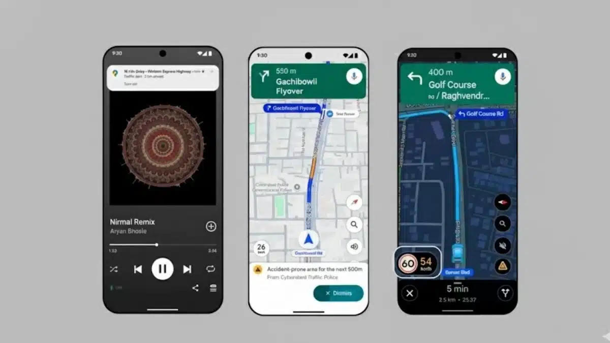
One of the biggest improvements coming from Gemini is the ability to speak naturally with Google Maps. Instead of short commands or fixed phrases, users can now give long or multi step voice requests. For example, a driver can ask for a vegan friendly restaurant along the route and also ask the app to check parking at the same time. Maps can understand the entire instruction and act on it.
This conversational style is aimed at reducing the need to touch the phone while driving. With more of the navigation process now controlled through voice, the driving experience becomes safer and smoother. Drivers can also report traffic disruptions by simply speaking out loud, such as informing Maps about an accident ahead on the road. This allows for quicker updates, more real time accuracy and a more helpful navigation environment for everybody using the app.
Another advantage is that users can complete common tasks inside Maps without switching apps. This includes creating reminders, checking events or asking for relevant suggestions related to the route. By combining navigation with natural conversations, Google is positioning Maps as more than just a location tool but a complete travel assistant.
Navigation Using Real World Landmarks
Google Maps is also starting to move away from generic distance based instructions and replacing them with real world references. Instead of telling a user to turn right in a specific number of metres or feet, Maps will now guide them using identifiable landmarks like restaurants, petrol stations or well known buildings.
This change makes navigation far easier in unfamiliar areas. A direction such as turn right after the Thai restaurant is clearer and more reassuring than a distance instruction that drivers often miss due to road conditions. This update is made possible because Google can analyse Street View images and millions of listed locations, allowing Gemini to identify important landmarks along each route.
Landmark based guidance brings Maps closer to how people naturally give directions. It improves confidence while driving and reduces confusion at complex intersections or crowded neighbourhoods. For users who often drive in new cities or busy areas, this feature can significantly improve the experience.
Proactive Alerts for Traffic Disruptions
Another important element of the Gemini update is the arrival of proactive alerts. Google Maps can now study a user’s usual routes and warn them about unexpected problems even when they are not actively navigating. If there is an accident, a closure or a major slowdown on a route someone often takes, the app can send an early notification.
This helps users plan better and avoid sudden delays. It also allows Maps to become more personalised with time. The app learns which areas matter most to a user and focuses on sending relevant alerts. For daily commuters, this can save time and reduce frustration during peak hours.
Proactive updates also reinforce the idea of Maps as a predictive tool rather than a reactive tool. Instead of waiting for users to open the app, Maps takes the initiative and delivers timely information based on real activity patterns.
Exploring Places With the Camera
The integration of Gemini with the phone camera adds another layer to the Maps experience. Users can point the phone at a shop, restaurant or local landmark and ask questions about it. Questions may include what is popular at this place or what the vibe of the location is like.
This feature uses the phone camera along with Google Lens and Gemini to bring instant information about real world environments. It makes exploration simple and interactive, especially for travellers or users discovering a new city. Instead of reading long lists or searching manually, the camera becomes the entry point to information.
By combining visual data with AI, Google removes the gap between the physical world and digital information. Users can learn more about their surroundings quickly and without typing or scrolling.
Integration With Other Google Apps
Google is also trying to make Maps more connected with other apps in the ecosystem. A driver can use their voice to add events to their calendar, check schedules or perform small tasks without leaving Maps. This helps reduce effort and improves the overall workflow while driving or travelling.
It creates a single environment where navigation, planning and management tasks can happen together. This makes travelling more organised and lets users stay focused on the road while still managing important updates.
The integration reflects Google’s broader strategy of linking its productivity tools with AI. With Gemini acting as the core engine, Google Maps becomes the central layer for daily movement and planning.
Why These Changes Matter
The updates are designed to make navigation easier, safer and smarter. Landmark based instructions help reduce confusion for drivers who rely on real objects rather than distances. Natural voice commands also reduce the need to look at the phone, which leads to safer driving conditions for everyone on the road.
Smarter suggestions along the route make journeys more convenient. Users get more meaningful recommendations such as food options, charging stations or rest stops without having to search manually. This also helps businesses with strong listings get more visibility through AI suggestions.
Proactive alerts save time and help users avoid sudden problems. Camera based exploration adds a new interactive experience for travellers. All these improvements make Maps more than just a tool for directions. It becomes a travel guide, assistant and information hub powered by Gemini’s intelligence.
What Users Should Keep in Mind
Some features are still rolling out and may not be available to all users immediately. Landmark style navigation, camera based exploration and advanced voice commands may reach certain countries first. Users should also check privacy and permissions since more features now rely on voice data, camera input and calendar integration.
Accuracy of AI results may vary, and connectivity plays a role in how well these features function. Offline navigation may still use basic systems without the advanced enhancements.
Language and region support will expand over time, but performance may differ based on local data quality. As these new features grow, users can expect more improvements across markets.
What Might Come Next
The next updates may include wider region support, better language recognition and deeper integration with cars through built in systems. Maps may introduce more real time visuals, improved lane assistance and new planning features powered by AI.
Developers using the Google ecosystem may also build apps that take advantage of Gemini and Maps together, which could lead to new tools for route planning, delivery services or local discovery.
As AI adoption increases, privacy and regulations will also become a central topic for mapping and travel technologies.
FAQs
Q1. What is the biggest change coming to Google Maps with Gemini?
A. The biggest change is the introduction of natural voice conversations that allow users to give long and complex instructions while driving.
Q2. How does landmark based navigation help?
A. It uses real world objects like restaurants or petrol stations to guide users, making directions easier to follow.
Q3. Can I explore places using my camera?
A. Yes, users can point the phone at a place and ask questions to get helpful information.
Q4. Are proactive traffic alerts automatic?
A. Yes, the app studies your usual routes and sends alerts even when you are not navigating.
Q5. Will these features be available everywhere soon?
A. The rollout may take time, and availability can vary by country and region.
Also Read- How To Update Play Store And Galaxy Store Apps On Your Galaxy Phone